- News
- Ankon Mitra unfolds maps, takes a step out of digital era
Ankon Mitra unfolds maps, takes a step out of digital era
Ankon Mitra's 'Maps Unfolded' exhibition at Kalakriti Art Gallery in Hyderabad aims to revive interest in traditional maps. The exhibit features innovative displays that transform 2D maps into immersive experiences, encouraging viewers to engage with and appreciate the intricate details and historical significance of cartography.

However, Delhi-based origami artist Ankon Mitra is out to prove the value of these maps through his latest exhibition, ‘Maps Unfolded,’ at the city’s Kalakriti Art Gallery. “A lot of people are not interested in studying maps. They get bored looking at the maps because they are two-dimensional,” says the architect-cum-landscape designer-cum-artist.
To change this norm, Mitra, along with exhibition curator Prashant Lahoti, is initiating a conversation on how art and maps can be brought into dialogue to engage people more. “When you have a map in front of you, the typical human tendency is to just scroll through it without paying much attention to its details. So one way to get their attention is to hold back information, like the globe, where you have to walk around it to see it completely. This helps people to engage more with the map,” says Mitra, pointing to one of the exhibits, ‘Tato Tessellations Maps.’ The word ‘tato’ has multiple meanings in different languages. In the Heian period of Japanese history, each tato was a kind of container or envelope and each map was folded into a geometric ‘envelope’ and these envelopes contained ‘mapped’ information.
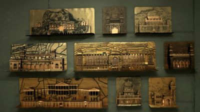
Explaining his point further, he walked over to another exhibit where Hyderabad’s heritage architecture is displayed in a pop-up series. “Archival and tourist maps of old Hyderabad are superimposed in golden Zardosi fabric with heritage buildings built on their location in the map. This method is known as architectural dioramas. People know the buildings, so this draws their attention to the map,” says the artist.
Like these exhibits, the gallery was filled with maps of all shapes and sizes, transforming the 2D works into new and immersive realms. “Before the time of Google Maps, people used to flip through map books. But with the digital age, the beauty of the map is fading. So the exhibition is an attempt to rekindle the joy of looking at maps and all their layers,” said Mitra.
Mitra, who took nearly nine months to put together the exhibition, said the maps are publicly available from the European Space Agency, Japan Aerospace Exploration Agency and even ISRO. “We also used some maps from the gallery’s archives as they have about 10,000 old maps. We also bought some maps.”
With the intention of gamifying maps and opening a gateway to the old and forgotten times, the exhibition will be open to the public till October 5.
End of Article
FOLLOW US ON SOCIAL MEDIA


