- News
- World News
- Rest of World News
- Hurricane John barrels toward Mexico’s southern coast after rapid intensification
Hurricane John barrels toward Mexico’s southern coast after rapid intensification
Hurricane John has rapidly intensified to Category 2 with winds up to 105 mph, threatening Mexico's southern coast. The US National Hurricane Centre warns of dangerous winds, storm surges, and potential flash floods. Authorities in Oaxaca and Guerrero have evacuated 3,000 people and established shelters as the region prepares for further disruption.

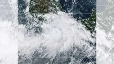
This National Oceanic and Atmospheric Administration satellite image shows Hurricane John near southern Mexico. (Picture credit: AP)
Hurricane John has intensified rapidly, posing a threat to Mexico's southern coast. The US National Hurricane Centre reported John had strengthened into a hurricane with winds up to 105 mph (165kmph).
As per the news agency AP, John was approximately 30 miles south of Punta Maldonado, moving north at 8 mph.
The hurricane was classified as Category 2 by Monday afternoon and was expected to become a major hurricane by late Monday or early Tuesday.
Authorities in Oaxaca and Guerrero responded swiftly. Oaxaca's governor reported the evacuation of 3,000 people and the setup of 80 shelters. Additionally, 1,000 military and state personnel were deployed.
Social media videos from Puerto Escondido showed tourists wading through heavy rain while local fishermen pulled boats ashore in preparation for the storm. With roads already compromised by recent rains, the region braces for further disruption.
The region was already challenged by previous heavy rains, leaving some roads in a difficult state. Last year, a similar rapidly intensifying hurricane, Otis, hit the area, causing severe damage and power outages which attracted criticism for the government's slow response.
However, this time President-elect Claudia Sheinbaum stated her government aims to improve the early alert system for hurricanes. John is expected to bring significant rainfall through Thursday, with up to 50 centimetres in some coastal areas of Oaxaca and Guerrero.
As per the news agency AP, John was approximately 30 miles south of Punta Maldonado, moving north at 8 mph.
The hurricane was classified as Category 2 by Monday afternoon and was expected to become a major hurricane by late Monday or early Tuesday.
Its landfall location remained uncertain due to shifting paths. The Centre warned of dangerous winds, storm surges and potential flash floods on Oaxaca's Pacific coast.
Meteorologist Matt Benz highlighted that warmer oceans contributed to the rapid intensification. "Rapid intensification has occurred more frequently in modern times as opposed to back in the historical record. So that's telling us there's something going on there," he said.
Authorities in Oaxaca and Guerrero responded swiftly. Oaxaca's governor reported the evacuation of 3,000 people and the setup of 80 shelters. Additionally, 1,000 military and state personnel were deployed.
Social media videos from Puerto Escondido showed tourists wading through heavy rain while local fishermen pulled boats ashore in preparation for the storm. With roads already compromised by recent rains, the region braces for further disruption.
The region was already challenged by previous heavy rains, leaving some roads in a difficult state. Last year, a similar rapidly intensifying hurricane, Otis, hit the area, causing severe damage and power outages which attracted criticism for the government's slow response.
However, this time President-elect Claudia Sheinbaum stated her government aims to improve the early alert system for hurricanes. John is expected to bring significant rainfall through Thursday, with up to 50 centimetres in some coastal areas of Oaxaca and Guerrero.
End of Article
FOLLOW US ON SOCIAL MEDIA


